Colorado State University predicts an extremely active hurricane season in 2024, estimating 11 hurricanes in the Atlantic Basin, the most ever predicted in their April outlook.
The report estimates the number of named storms, hurricanes, and major hurricanes, as well as the likelihood of landfall in vulnerable areas. It also examines important factors, such as sea-surface temperatures in the Atlantic.
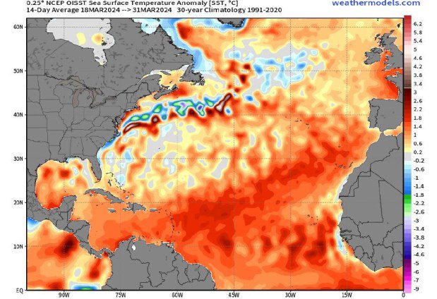
Phil Klotzbach, an atmospheric researcher at Colorado State University, said that the current sea surface temperature in the Atlantic is setting the stage for an active season in 2024. Even if the Atlantic warms at the slowest rate ever into the peak of the season, the temperatures would still be among the warmest. The report forecasts 1.5 degrees Celsius warmer than normal sea surface temperatures, which is significant.
The numbers
The research team predicts 23 named storms for 2024.
The average from 1991 to 2020 is 14.4, and the active 2023 Atlantic season saw 20 storms.
The report said that eleven of those storms will likely become hurricanes, with winds of 74 mph or more.
The average from 1991 to 2020 is 7.2, and 2023 had seven.
Additionally, the report expects five of the hurricanes to reach major hurricane strength, with sustained winds of 111 mph or greater.
The average from 1991 to 2020 is 3.2, and 2023 had three.
Previously, the highest number of hurricanes that Colorado State ever predicted was nine, in 1995, which ended up with 11 hurricanes.
The Colorado team forecasts that hurricane activity in 2024 will be quite high — about 170% of the average season from 1991 to 2020.
In 2023, activity was about 120% of the average season.
The report also includes the probability of major hurricanes making landfall, with a 34% chance along the U.S. East Coast, including the Florida peninsula.
The average from 1880–2020 is 21%.
On the Gulf side from the Florida Panhandle to the Texas-Mexico border, there are 42% odds.
The average from 1880 to 2020 was 27%.
Another statistic the report focused on was the chances of a storm tracking within 50 miles of a given state.
Florida showed the highest risk in those forecasts, with a 75% chance of a hurricane tracking within 50 miles of its coast.
Florida also had a 44% chance of a major hurricane tracking within 50 miles of its coast.
Sea surface temperatures are at record warm levels this spring across most of the tropical and the eastern part of the subtropical Atlantic. A map shows higher than normal anomaly rates during late March, 2024. The warmer the color, the higher the anomaly above the norm from1991 to 2020.

The factors
Phil Klotzbach, who leads the project at Colorado State University, said that what is most remarkable about 2024 is how warm the Atlantic currently is. Even if the tropical Atlantic warms at the slowest rate observed between now and the peak of the Atlantic hurricane season, it would still be one of the warmest tropical Atlantic hurricane seasons on record.
This warm water has several consequences.
Warm ocean waters provide energy for hurricanes, so a very warm Atlantic indicates a season that is likely to be above average.
The high temperatures of the sea surface in the Atlantic also lead to a more unstable atmosphere, which is favorable for hurricanes.
The exceptionally warm water temperatures in the eastern, central tropical, and subtropical Atlantic this spring have an additional impact: a weaker subtropical (Bermuda) high, which in turn means weaker trade winds. Less wind leads to more heat in the water. The report stated that these conditions are likely to result in continued well above-average water temperatures in the tropical Atlantic during the peak of the 2024 Atlantic hurricane season.
El Niño and La Niña
Forecasters are expecting the El Niño, which brought South Florida a relatively wet winter, to weaken soon and likely shift to a La Niña by the peak hurricane season from August through October.
La Niñas typically decrease wind shear over the Atlantic. Wind shear disrupts hurricanes, so if a La Niña forms, it may promote the formation of hurricanes.
The report stated that with the signals favoring hurricanes – an extremely warm Atlantic and a likely developing La Niña – the forecast team is highly confident that the 2024 Atlantic hurricane season will be very active, based on their April outlook.
Klotzbach also noted that it's still quite some time until the start of the season, and later forecasts will be more accurate. “There’s still a lot that can change.”
According to a report from Colorado State University, they are predicting 11 hurricanes for this year, which is the most they have ever forecasted. They also suggested that five of those storms could be major hurricanes of Category 3, 4, and 5.


